IDRISI Taiga 16.0

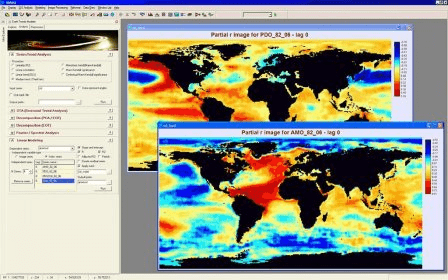
IDRISI Taiga is an integrated GIS and Image Processing software
4 
Rating
Your vote:
Latest version:
16.05 See all
Developer:
Clark Labs / Clark University
Screenshots
1 / 1
Commercial
Used by 3 people
Request
Download
link when available

IDRISI Taiga is an integrated GIS and Image Processing software solution providing nearly 300 modules for the analysis and display of digital spatial information. IDRISI offers the most extensive set of GIS and Image Processing tools in the industry in a single, affordable package. With IDRISI, all analytical features come standard—there is no need to buy costly add-ons to extend your research capabilities.

Comments (2)

User

Your vote:

W
rating winkyihtut
The best SW already purchased by me last 10yrs ago.

Sep 19, 2023 Was it helpful?  yes(0) no(0) | Reply
K
Kyihtutwin
Can I use IDRISI Taigba 16.0 if I change window 7 ,32bit to window 10_ 64bit?
I already used window 7 utimate, 32. But it's just happened to change window 10 or more.
Please give me the way to proceed. I have got that IDRISI Taiga software from Clark Lab.
Many thanks,
kyihtutwin

Sep 19, 2023 Was it helpful?  yes(0) no(0) | Reply

Facebook comments

Related software

GRASS GIS
GRASS GIS
Free
rating

Contains over 350 modules to render maps and images on monitor and paper.

Quantum GIS
Quantum GIS
Free
rating

Provides a continously growing number of capabilities provided by core functions

Taiga
Taiga
Free
rating

Lightweight anime tracker for Windows users.

DIVA-GIS Annapurna
DIVA-GIS Annapurna
Free
rating

DIVA-GIS can be used to map and analyze biological distribution data.

Christine-GIS
Christine-GIS
Free
rating

Combines visual geographic information with sophisticated computer applications.